

Each project has its own specifications and requirements, and no two are alike in detail. However, typical studies can be classified in terms of scale:

Regional
Large-scale regional surveys, mostly airborne, are usually conducted as reconnaissance studies for exploration, e.g. for minerals, hydrocarbons, water or geothermal potential. Gravity, magnetics and EM are typical methods that provide an overview of the tectonic setting, delineation of faults or localisation of prospective sites.
To reliably filter, differentiate and transform gravity, magnetic and EM field data, more than just the area of interest is required due to off-model effects. Regional surveys are often available free of charge to the public and are thus a helpful complement to the high accuracy survey data, which is usually only available in the area of focus. Merging the two data sets can sometimes be a challenge, – which can be solved, e.g. by using an approach with equivalent sources. Since large scale effects from outside the model can have a significant impact in the model domain, they need to be reduced during modelling. Knowing the shape of the gravity, magnetic and EM fields outside the model is a good consistency check for the eliminated regional fields.
Prospect
Prospective studies are used to delineate regions with specific signatures and to identify areas of interest. Knowing the distribution of anomalies allows for efficient positioning of small-scale follow-up surveys and/or seismic and borehole programmes, which are usually much more expensive than gravity, magnetic and EM surveys. Sometimes coarse models are constructed in regional studies to test specific prospect scenarios or define sensitivities.
Typical applications are, e.g. studies to geometrically define salt structures for their potential use as gas or hydrogen storage – or to improve the velocity model to enhance seismic imaging for pre-salt hydrocarbon deposits.

Reservoir
Reservoir studies usually have a denser station spacing than prospect studies. This ensures that all relevant structures can be resolved in the model cube (if their density/susceptibility/resistivity contrast is sufficiently high). The measurements must be of high quality and accuracy, and all processing steps have to be carried out carefully.
Especially for reservoir monitoring, repeated time-lapse surveys beyond seismics are a valuable complementary contribution to improve interpretation in order to reduce ambiguity and risk. 4D EM or gravity programmes have the potential to support not only hydrocarbon production but also, e.g. CO2 sequestration projects.
Near-Surface
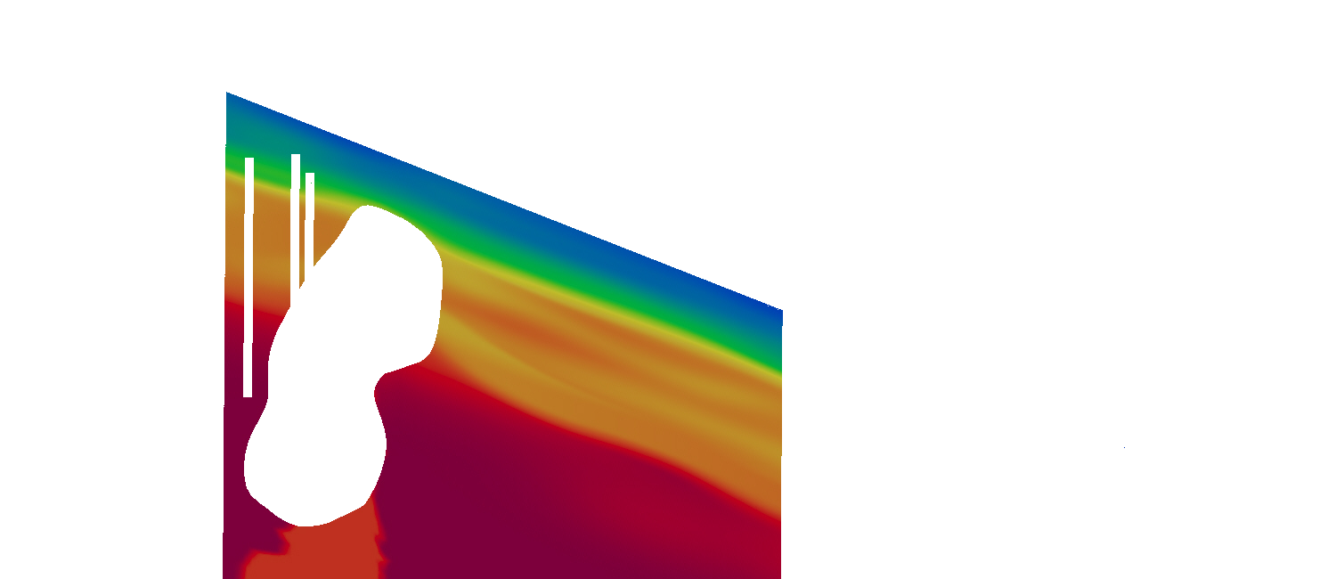
For near-surface applications, a very dense station spacing is required. Often these studies search for or investigate isolated objects such as cavities, pipelines or unexploded ordnance. Gravity, magnetic and EM measurements are ideal methods to scan a limited area without the risk of missing critical zones. Besides adapted data analysis tools, direct methods can also be useful in these cases, as the problem can often be approximated by a simple model. For example, a follow up borehole programme can be significantly reduced to the zones identified by the geophysical ground survey.
Another example of a near-surface task is to reduce the effects of shallow sediments for a larger model in order to improve reliability, e.g. by more accurate statics for seismic processing.
